Delete
- Forums
- Forums
- Awards and Honors
- Thread ARCHIVE and Hall of Fame Threads
- Hall of Shame and Amusing Oddities
You are using an out of date browser. It may not display this or other websites correctly.
You should upgrade or use an alternative browser.
You should upgrade or use an alternative browser.
The earth is flat and we never went to the moon
- Thread starter DFT_Dave
- Start date
- Status
- Not open for further replies.
I have problems with this illustration.
The sun and the moon are the same size viewed from earth.
Why is the sun depicted to be larger than the earth and the moon smaller than the earth?
I see deception here.
View attachment 25551
--Dave
Because that image, which is based on the globe earth model, is not to scale, if it were, you would only be able to see the sun, and the earth would just be a tiny speck that's really far away from it. You could not be able to see the moon.
You could search online for making a scale model of the solar system. It's something my science class did back in 7th or 8th grade. The objects we used were small, the sun being the only exception, and we went outside to the sidewalk in front of the school and placed the objects in order and at appropriate distances.
The scale of the solar system is absolutely massive, Dave. I don't think you fully comprehend just how massive, so I'm going to give you a link that has the actual and scaled sizes for you to experiment with.
http://blair.pha.jhu.edu/scale.html
You might understand then why the drawing you shared is not to scale.
| (Note: I am not, in this post, saying that (to keep this fair to the discussion) this experiment proves the round earth, I am only presenting it so that there is no confusion as to what a solar system model would look like if the earth was indeed round.) |
If you can't explain the problem just say so.
--Dave
I just woke up, and misread your comment. Hence why I deleted my comment.
Funny story about this...
I once tried to make a model of the solar system in Unity3D once. I went really small, making the sun about 1 dm (iirc, or it might have been 1 cm, though I do remember using that link I provided in my previous comment to determine scale). But I had trouble making the planets because, and I realize this now, I went too small, and I couldn't even see them after I made them to scale and placed them, and to this day I still have no idea whether it was because they were too small to see, or if they were farther away than I originally thought they were going to be.
I once tried to make a model of the solar system in Unity3D once. I went really small, making the sun about 1 dm (iirc, or it might have been 1 cm, though I do remember using that link I provided in my previous comment to determine scale). But I had trouble making the planets because, and I realize this now, I went too small, and I couldn't even see them after I made them to scale and placed them, and to this day I still have no idea whether it was because they were too small to see, or if they were farther away than I originally thought they were going to be.
Because that image, which is based on the globe earth model, is not to scale, if it were, you would only be able to see the sun, and the earth would just be a tiny speck that's really far away from it. You could not be able to see the moon.
You could search online for making a scale model of the solar system. It's something my science class did back in 7th or 8th grade. The objects we used were small, the sun being the only exception, and we went outside to the sidewalk in front of the school and placed the objects in order and at appropriate distances.
The scale of the solar system is absolutely massive, Dave. I don't think you fully comprehend just how massive, so I'm going to give you a link that has the actual and scaled sizes for you to experiment with.
http://blair.pha.jhu.edu/scale.html
You might understand then why the drawing you shared is not to scale.
(Note: I am not, in this post, saying that (to keep this fair to the discussion) this experiment proves the round earth, I am only presenting it so that there is no confusion as to what a solar system model would look like if the earth was indeed round.)
I just woke up, and misread your comment. Hence why I deleted my comment.
That's better. My concern is the umbra and pre umbra. Pre umbra is, simply, the sun rise, right?
--Dave
Sent from my iPhone using TOL
")
musterion
Well-known member
No. There is more land beyond the wall of ice that surrounds the flat earth. No one knows how far it extends.
--Dave
Invisible ice walls again? No one has ever seen such. You've placed your faith in idle speculations and presume to stamp God's approval on them. Beware the compounding of error - it only and always leads to more error.
I played a lot of baseball and basketball and if some asked me, "what is the shape of the baseball or basketball" I would have said "round". I would not have said it was a sphere. Sorry for the confusion. I was a jock, not a nerd when I was a kid.
--Dave
Thanks for confirming in your own words the correct translation. There is a word for circle, sphere, and ball according to detractors in the debate about sitting above the sphere of the earth. The word for sphere is also used as circle because that is what it looks like at distance.
Invisible ice walls again? No one has ever seen such. You've placed your faith in idle speculations and presume to stamp God's approval on them. Beware the compounding of error - it only and always leads to more error.
Look up on google "Antarctic Ice Wall" it is very visible. Does it surround the entire flat earth or is it only surround the bottom of the globes earth is the question.
--Dave
Sent from my iPhone using TOL
You mean "penumbra"?That's better. My concern is the umbra and pre umbra. Pre umbra is, simply, the sun rise, right?
--Dave
Sent from my iPhone using TOL
You're wondering about why if the moon orbits the earth does it not always fall in the earth's shadow when the Earth is (relatively) between the moon and Sun, correct?
If so, you can show yourself why, using the following experiment:
Take a lamp (the bigger the better), and put it in one corner of a room, or better yet at the end of a hallway, facing the center/middle. Now take a basketball and place it towards the middle of the room at about the same height. Then take a tennis ball, and place it on the opposite side of the basketball from the lamp about 24 feet from the basketball, raising it 2.1 feet above the line made by the "sun" and the "earth." Experiment by raising and lowering the "moon" to simulate different times of the year, when the moon is at different angles (because the angle of the orbit does not change, just the direction in relation to the imaginary line made by the sun and the earth). Now do you see why in the solar system model the moon isn't always hidden in earth's shadow?
Last edited:
musterion
Well-known member
Look up on google "Antarctic Ice Wall" it is very visible.
No, because all I'll get is links to people like you, whose minds are already made up.
Want to start to convince people here? Find a non-flat earth source that acknowledges the existence of an actual ice WALL that is not simply ice at the poles.
And like I said earlier, if a camera is sent high enough, one of them should be able to see this ice wall in a location it shouldn't be on a globe. Astronauts should easily see it. None of them have.
Why doesn't anyone know how far it extends?No. There is more land beyond the wall of ice that surrounds the flat earth. No one knows how far it extends.
--Dave
I don't know if the page exists or not anymore, but I once googoled something like "solar system to scale" and the web page author had layed out from top to bottom from the Sun to Pluto to scale, and it was amazing to me how many blank page-downs there were between planets. Their distance apart is many orders of magnitude more than their diameters, as you're indicating here. By comparison, those "solar system models" in science stores are closer to having all the planets orbiting within the orbit of Mercury.Funny story about this...
I once tried to make a model of the solar system in Unity3D once. I went really small, making the sun about 1 dm (iirc, or it might have been 1 cm, though I do remember using that link I provided in my previous comment to determine scale). But I had trouble making the planets because, and I realize this now, I went too small, and I couldn't even see them after I made them to scale and placed them, and to this day I still have no idea whether it was because they were too small to see, or if they were farther away than I originally thought they were going to be.
Here's one... Not the one I was looking for, but it'll work... (it scrolls sideways)I don't know if the page exists or not anymore, but I once googoled something like "solar system to scale" and the web page author had layed out from top to bottom from the Sun to Pluto to scale, and it was amazing to me how many blank page-downs there were between planets. Their distance apart is many orders of magnitude more than their diameters, as you're indicating here. By comparison, those "solar system models" in science stores are closer to having all the planets orbiting within the orbit of Mercury.
http://www.phrenopolis.com/perspective/solarsystem/
Here's the one I was looking for:I don't know if the page exists or not anymore, but I once googoled something like "solar system to scale" and the web page author had layed out from top to bottom from the Sun to Pluto to scale, and it was amazing to me how many blank page-downs there were between planets. Their distance apart is many orders of magnitude more than their diameters, as you're indicating here. By comparison, those "solar system models" in science stores are closer to having all the planets orbiting within the orbit of Mercury.
http://joshworth.com/dev/pixelspace/pixelspace_solarsystem.html
Derf
Well-known member
[MENTION=4980]DFT_Dave[/MENTION],
Have you looked into Great Circle distances? Great Circle distances are used by pilots all the time to reduce flight times. In plane geometry, the shortest distance between two points is a straight line. So if I wanted to go from Los Angeles to New York, I could spread a map on a table and draw a line. That line would presumably be the shortest flight between LA and NY. But flights between LA and NY go a shorter distance than that by veering north.
From what I saw at the Flat Earth Wiki site, the northward veering flight paths might make some sense, because "north" is in the middle of the flat map. But now consider Great Circle flight paths south of the equator. Going from, say, Sydney, Australia to Buenos Aires, pilots save fuel by taking a shorter route veering south from the flat map straight lines, something that would increase the distance in any flat earth model that does not have Antarctica as its center (which is hard to do if the ice wall holding in the oceans is at the center of the world).
Here's a map of the flat earth from wiki.tfes.org:
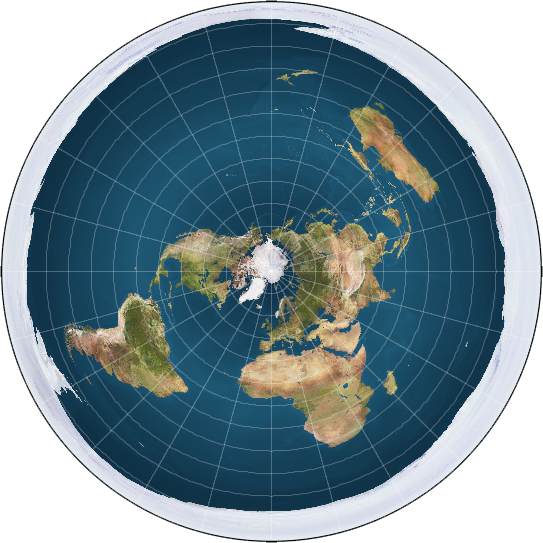
You can see that Australia is at the top right and South America is at the bottom left. The straightest flight path, and thus the one that would save most on fuel, is directly through the Arctic (not the Antarctic). But I can guarantee you that doing so will waste all kinds of fuel in the real world, and no airlines do it. Instead, Great Circle routes south of the equator consistently veer closer to Antarctica, which would make the travel much longer in the flat earth model, as depicted.
I'm sure the outstandingly brilliant CEOs of airlines, like United Airlines for instance, would never waste so much money on fuel, especially when they can just kick people off flights to save some money and time.
Have you looked into Great Circle distances? Great Circle distances are used by pilots all the time to reduce flight times. In plane geometry, the shortest distance between two points is a straight line. So if I wanted to go from Los Angeles to New York, I could spread a map on a table and draw a line. That line would presumably be the shortest flight between LA and NY. But flights between LA and NY go a shorter distance than that by veering north.
From what I saw at the Flat Earth Wiki site, the northward veering flight paths might make some sense, because "north" is in the middle of the flat map. But now consider Great Circle flight paths south of the equator. Going from, say, Sydney, Australia to Buenos Aires, pilots save fuel by taking a shorter route veering south from the flat map straight lines, something that would increase the distance in any flat earth model that does not have Antarctica as its center (which is hard to do if the ice wall holding in the oceans is at the center of the world).
Here's a map of the flat earth from wiki.tfes.org:
You can see that Australia is at the top right and South America is at the bottom left. The straightest flight path, and thus the one that would save most on fuel, is directly through the Arctic (not the Antarctic). But I can guarantee you that doing so will waste all kinds of fuel in the real world, and no airlines do it. Instead, Great Circle routes south of the equator consistently veer closer to Antarctica, which would make the travel much longer in the flat earth model, as depicted.
I'm sure the outstandingly brilliant CEOs of airlines, like United Airlines for instance, would never waste so much money on fuel, especially when they can just kick people off flights to save some money and time.
[MENTION=4980]DFT_Dave[/MENTION],
Have you looked into Great Circle distances? Great Circle distances are used by pilots all the time to reduce flight times. In plane geometry, the shortest distance between two points is a straight line. So if I wanted to go from Los Angeles to New York, I could spread a map on a table and draw a line. That line would presumably be the shortest flight between LA and NY. But flights between LA and NY go a shorter distance than that by veering north.
From what I saw at the Flat Earth Wiki site, the northward veering flight paths might make some sense, because "north" is in the middle of the flat map. But now consider Great Circle flight paths south of the equator. Going from, say, Sydney, Australia to Buenos Aires, pilots save fuel by taking a shorter route veering south from the flat map straight lines, something that would increase the distance in any flat earth model that does not have Antarctica as its center (which is hard to do if the ice wall holding in the oceans is at the center of the world).
Here's a map of the flat earth from wiki.tfes.org:
You can see that Australia is at the top right and South America is at the bottom left. The straightest flight path, and thus the one that would save most on fuel, is directly through the Arctic (not the Antarctic). But I can guarantee you that doing so will waste all kinds of fuel in the real world, and no airlines do it. Instead, Great Circle routes south of the equator consistently veer closer to Antarctica, which would make the travel much longer in the flat earth model, as depicted.
I'm sure the outstandingly brilliant CEOs of airlines, like United Airlines for instance, would never waste so much money on fuel, especially when they can just kick people off flights to save some money and time.
Derf
Well-known member
Sure there is: "stand still" is an anthropomorphism. And we know those never refer to actual reality!There is never a hint that this is merely phenomenological language. It is reality as God has revealed it.
Derf
Well-known member
Sorry, I missed that one--you usually explain yourself so much better. But I think I added something important, as the northern hemisphere Great Circle routes always bend north, which, though the scale is off the closer you get to the equator, is also what the flat earth map would predict.<other quotes>
Last edited:
- Status
- Not open for further replies.